
Spring has arrived in the mountains, with green grass on the rolling hills of Kananaskis and flowers covering the slopes. In this guide, I’ve featured five of my favorite spring hikes that are just a little bit off the beaten path. We’ve all hiked Troll Falls and Heart Creek dozens of times, so I encourage you to choose one new hike this spring to complete with your family.
\n \nI’ve also included three hikes in southern Kananaskis that are much easier to reach now that we have a completed ring road in the city. I recommend heading west of Diamond Valley at least once this spring or summer to hike and explore a new trail.
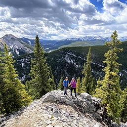
\n1. White Buddha to Vents Ridge, Elbow Valley
\nThis hike starts from the Powderface Creek Trailhead just up the road from Elbow Falls. The parking lot is small, so if you can’t find space, park at the Elbow Falls parking lot and walk further up the highway for five minutes.
\nThe name "White Buddha" comes from the climbing crag you'll pass by before you climb to the top of the ridge. If you see climbers, give them space and watch for falling rocks. Do not stop near them to have your lunch. Wait until you reach the top of the ridge.
\nThis hike is only 4km return with 300m of elevation gain, but it is strenuous once you start climbing from Powderface Creek up to the White Buddha cliffs. Expect steep sections with loose rock. This hike may not be suitable for young children. The views from the top of Vents Ridge, however, are stunning and I enjoy this hike every spring.
\nI recommend downloading the map on AllTrails so that you’ll be able to see where the White Buddha trail leaves Powderface Creek. This is an unofficial trail with no signage. There are a few different routes on AllTrails for this hike, but you want to look up: White Buddha Via Powderface Creek Trail. Return the same way.
\n2. Bow Valley Provincial Park Campground Loop
\nThis is an easy loop with many options to shorten the hike. Park at Middle Lake, just outside the Bow Valley Campground off Highway 1X. From here, I like to hike the Elk Flats, Many Springs, Whitefish, Bow River, and Montane Trails in a clockwise loop. The loop is 9km in length with only 150m of elevation gain. There are no steep hills and if you like flowers, you’ll find many kinds of wild orchids, including bright yellow lady slippers, by the beginning of June.
\nAll of the trails above can also be hiked individually (especially the Many Springs Trail) with young children. There is a dedicated parking lot for the Many Springs Trail and it is a lovely, flat 1.6km loop. In June, it’s wildflower heaven!
\nThere is also a beautiful picnic area by the Whitefish Day Use Area beside the Bow River (with parking lot).
\nAnd if you’re camping at the Bow Valley Campground, you’ll be able to access all of these trails right from your campsite.
\nThese trails don’t show up on the AllTrails as a complete loop, but individual trails can be found on the app. There are also official signs along the loop.
\n3. High Noon Hills, Sandy McNabb Campground Area
\nThis is an easy hike in southern Kananaskis off Highway 546, west of Diamond Valley, and a favorite of mine for wildflowers by late May. It’s a short, half-day hike and there's a fire pit at the top so you can bring firewood, marshmallows, and hot dogs with you for a family picnic. You’ll want to pack water with you to fully extinguish your fire afterwards.
\nThe hike is 5km return with 200m of elevation gain if you turn around at the top of the main hill. Loops and additional extensions are possible by experienced hikers with route finding experience. Find the hike on AllTrails by looking up: High Noon Trail. I highly recommend downloading the map because this is an unofficial hike with no signage on the trail. Also, there is no official parking lot. You’ll park on the side of the highway for this one and you’ll need to consult the map to get that location.
\nIt is also important to note that you can turn around anywhere. The AllTrails track goes beyond the highest hill.
\n4. Dyson Falls, Bluerock Wildland Provincial Park
\nThis popular hike is located in south Kananaskis and is accessible after May 15 from the Indian Oils parking lot on Highway 546, west of Diamond Valley. The hike is 8km round trip with 300m of elevation gain, but the trail is never steep and you’ll be following the wide “Sheep Trail” until you come to the river crossing and beautiful Dyson Falls (where you’ll turn around).
\nYou'll also pass by Tiger Jaw Falls right at the beginning underneath a bridge over the Sheep River. Find the trail on AllTrails by looking up: Dyson Falls via Sheep Trail and Green Mountain. There is minimal signage once you leave the parking lot, so having the map downloaded could be helpful.
\n5. Missinglink Mountain, Bluerock Wildland Provincial Park
\nFinally, this is the third hike off Highway 546, also accessible after May 15. It’s more challenging than the previous two hikes and better suited to school-aged children who can handle a bit of steep climbing. The hike is a 4km return trip with 300m of elevation gain. You’ll be following a good trail the entire time, but you’ll definitely feel like you’re climbing a mountain.
\nThere is an official parking lot for this one at the Gorge Creek Trailhead off the Gorge Creek Road (a rough gravel road off Highway 546). The road ends at this parking lot so you can’t accidentally miss it. From the parking lot, cross the road and you’ll find the trail on the other side. There are many trails that leave from this trailhead, so make sure you cross the road or you’ll be heading for Mt. Ware or Volcano Ridge instead.
\nI recommend downloading the AllTrails map to guarantee you find the correct trail. Once you’re on the Missinglink trail, you’ll be good and there’s no way to get lost. Find the hike by looking up: Missinglink Mountain. Note there are other routes for this mountain, so make sure you’re following the one that starts from Gorge Creek. It is by far the easiest route.
\nReturn the same way once you reach the top. Don’t attempt to descend via any other routes without significant route finding experience – trust me on that.
\nAnd don’t forget…
\nDon’t forget to purchase a Kananaskis Conservation Pass for the day before you go. It is required to park at all trailheads. You can also purchase an annual pass. Visit the following website to purchase your pass: alberta.ca/kananaskis-conservation-pass
\nI also recommend carrying bear spray for all hikes in Kananaskis. Know how to use it. You can purchase it at any outdoor store.
\n\n
Tanya is a freelance writer and mom to a spunky boy. She loves hiking, camping, skiing, and all things mountain-related. She is the author of the blog Family Adventures in the Canadian Rockies, rockiesfamilyadventures.com. You can find her on Instagram @MountainMomYYC.
\n\n
See our related articles:
\n


Calgary’s Child Magazine © 2025 Calgary’s Child
